The gap between official West Coast Trail campsites is quite large after Tsusiat Falls at 25km. The next campsite heading south is the crowded and ugly one at Cribs Creek at 41.5km, followed by Carmanah Creek at 46km. Tsusiat to Carmanah is a fairly long distance at 21km, but if you camp at Cribs Creek like everyone else, you only reduce the distance by only 5km. The 5km is almost entirely beach as well which is fairly relaxing.
 Tsusiat Falls is a stunning place to start your day
- Eat breakfast and watch for whales passing by
- Hole in the Wall is a gorgeous rock formation to see
- The Crab Shack serves crab and chicken dinners
- Much of your days hiking is easy and scenic
- Carmanah Lighthouse can be visited(grounds only)
- Chez Monique's sells meals & drinks
- Carmanah Creek campsite is wonderful & quiet
- Beautiful, long sandy beaches are frequent
 Massive 17 kilometre gap between campsites
The West Coast Trail
 Prologue 1: The West Coast Trail 2: When to Hike & Fees 3: Trailheads 4: Getting There 5: Considerations 6: Campsites 7: Shipwrecks 8: Routes
  Day 1 Pachena to Darling Day 2 Darling to Tsusiat Day 3 Tsusiat to Carmanah Day 4 Carmanah to Walbran Day 5 Walbran to Cullite Day 6 Cullite to Camper Day 7 Camper to Thrasher
  Michigan Creek at 12k Darling River at 14k Orange Juice Creek at 15k Tsocowis Creek at 16.5k Klanawa River at 23k Tsusiat Falls at 25k Cribs Creek at 42k Carmanah Creek at 46k Bonilla Creek at 48k Walbran Creek at 53k Cullite Cove at 58k Camper Bay at 62k Thrasher Cove at 70k
The hike from Tsusiat begins with a choice of walking along the beach or through the forest. The forest route is pretty challenging and the beach route is pretty relaxing. You climb into the forest at 29.2km and hike 3km of challenging jungle hiking to arrive at the Nitinat Narrows crossing. The inland trail is fairly easy as you pass through two First Nations regions, Whyac and Clo-oose. You then start a gorgeous section of beach from 36km to 38km. The beach section here is very nice as it is wide, sandy and goes on and on. The beach hiking is very relaxing and there is a detour inland just past the 38k mark, then you again have a choice of inland, forest route or the lovely beach route. At 40km you come to Dare Beach, or if you take the forest route, you will see it from high above on the bridge crossing Dare Creek. Dare Beach is an unofficial campsite along the West Coast Trail. You are allowed to camp there, but it not on the maps for some reason. Dare Beach is an excellent option to camp if you don't want to continue six more kilometres to Carmanah Creek at 46km. If you do continue on you will reach the campsite at Cribs Creek at 41.5km. Cribs Creek is a shallow creek that passes alongside the beach campsite to the ocean. The Cribs Creek campsite should be avoided if possible because it is always busy and the beach is not very pretty. Because the enormous gap to the Tsusiat Falls campsite heading north, everyone camps at Cribs and Tsusiat.
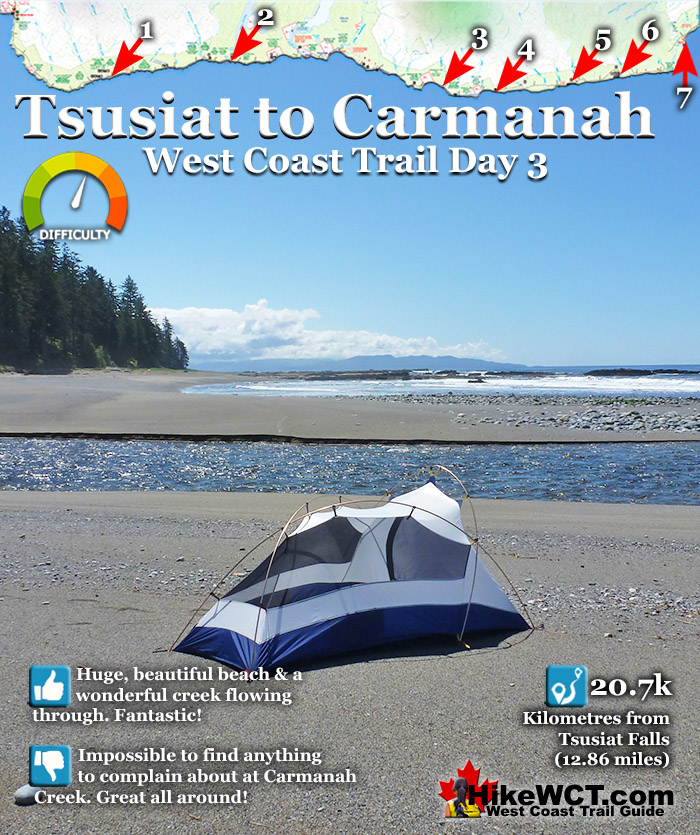
Day 3: Tsusiat to Carmanah on the West Coast Trail
The campsite at Tsusiat stretches far along the beach, so it can accommodate a tremendous number of campers. At Cribs Creek, however, the beach is narrow along the shore and hemmed in by an uninviting rocky shelf at the water. If you have the energy and desire, you could hike an extra 3.7k to the stunningly beautiful campsite at Carmanah Creek. Relatively few people camp here because everyone camps at Cribs Creek. Carmanah Creek is very pretty and the wonderful sandy beach extends in both directions as far as the eye can see. If you are keen to eat at Chez Monique's, you will be just a 20 minute walk away. Chez Monique's is a beach restaurant on First Nations reserve land and sells burgers, beer and quite a lot more.

Day 3 Tsusiat to Carmanah Continued...
Day 1 Pachena to Darling Day 2 Darling to Tsusiat Day 3 Tsusiat to Carmanah Day 4 Carmanah to Walbran Day 5 Walbran to Cullite Day 6 Cullite to Camper Day 7 Camper to Thrasher
Michigan Creek at 12k Darling River at 14k Orange Juice Creek at 15k Tsocowis Creek at 16.5k Klanawa River at 23k Tsusiat Falls at 25k Cribs Creek at 42k Carmanah Creek at 46k Bonilla Creek at 48k Walbran Creek at 53k Cullite Cove at 58k Camper Bay at 62k Thrasher Cove at 70k
Prologue 1: The West Coast Trail 2: When to Hike & Fees 3: Trailheads 4: Getting There 5: Considerations 6: Campsites 7: Shipwrecks 8: Routes