Clayoquot Sound has a staggering array of hiking trails within it. Between Tofino and Ucluelet, Pacific Rim National Park has several wilderness and beach trails, each one radically different from the last. The islands in the area are often separate Provincial Parks.
TheWestCoastTrail
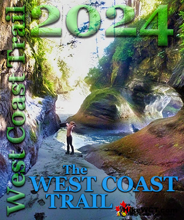
The extraordinary West Coast Trail is found not far from Ucluelet. Bamfield is home to the northern trailhead to this wonderful trail known for its 80 foot ladders, stunning beaches and regular encounters with shipwrecks from the Graveyard of the Pacific.
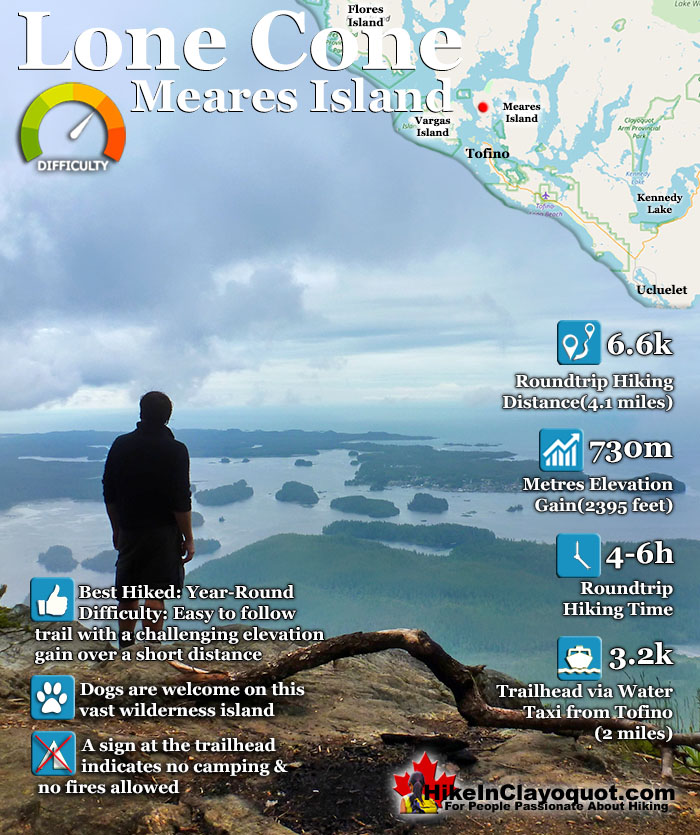
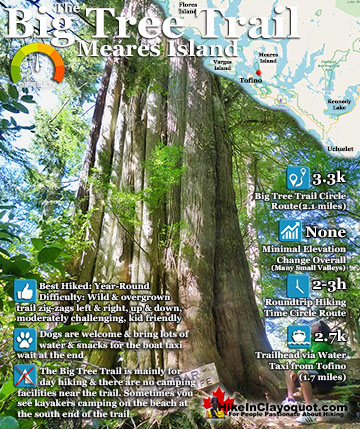
Lone Cone is the wonderful cone shaped mountain that dominates the skyline in Tofino. It is just 6k from Tofino on the north-western end of Meares Island. Lone Cone is an incredible hike to do while in Tofino. There are several attributes that make it fantastic. First, its location. Very close to Tofino. Just a short and very scenic boat taxi takes you to the trailhead.
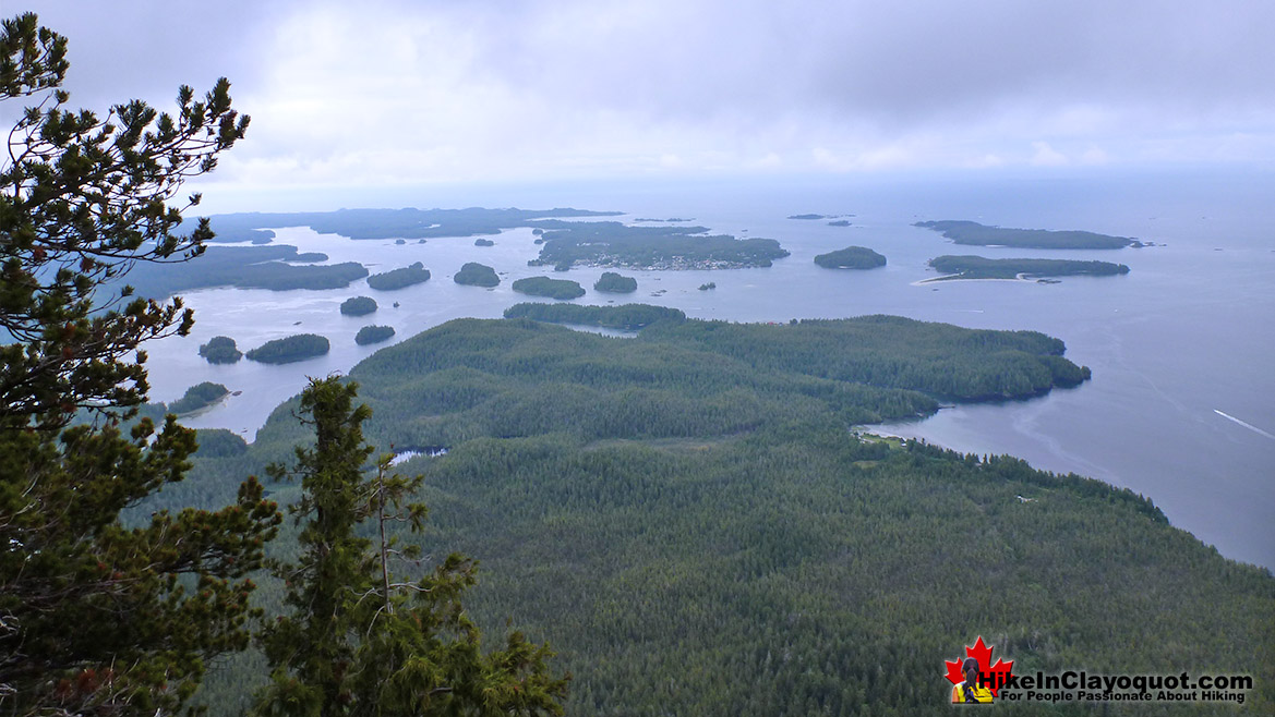
Second, is it is such an abruptly steep hike that you go from the ocean to absurdly sweeping views in just over an hour. Due to the location of Lone Cone requiring a water taxi to access, ensures that it remains serene and quiet most days. In the 15 minute, fast taxi, you will see a quick look at the spectacular scenery that has made Tofino famous. Small and large islands crammed almost solid with beautifully huge trees. Sandy beaches that make you think more that you are in Hawaii than in Canada. Abrupt, rocky outcrops with chaotic, swirling, clear and green water that the boat taxi/tour guide continuously points to unexpectedly beautiful creatures lurking in. Then you look up in the trees and spot a resident eagle staring menacingly down from a tree branch next to its nest full of offspring. And that's just the first five minutes from the pier. 15 minutes from the pier you arrive at the grungy, though at the same time, strangely beautiful pier at the now abandoned town, Kakawis. There are still a few dozen houses that line the gravel road you will see as you make your way to the trailhead. In 2013 another trailhead was opened closer to Tofino but much further from Lone Cone. This trailhead also has a $5 fee to access.
From the pier you follow the gravel road which seems to take you further from Lone Cone. About five minutes down this road you will see the houses of Kakawis on your right, and keeping on the gravel road you will soon see the large "Lone Cone" sign pointing you left to the very well marked trail into the deep forest and muddy first section of the trail. Though there has been a fair amount of mud avoiding constructions you still might get a bit muddy here. Though you can hop from one tree root to another fairly effectively, a couple slips and stumbles may get you wet and dirty. 1.2k into the hike (from the pier), you finally begin ascending. Slowly at first then at 1.8k steeper and steeper. From this point until the end of the trail the hike averages about 45 degrees! Lone Cone is, near and at the top, quite massive. And though the marked trail ends and the amazing views the exploring has just begun. You could wander for hours through the forest at the top, however, the viewpoints on the marked trail are hard to beat.
At the main viewpoint the is a small and evidently well used place for a fire right at the edge of the cliff. This area also, if you were inclined, have room for a tent or two, though you read at the trailhead that camping is prohibited. There are several suitable places to put your tent if you are keen further into the bush past this viewpoint. The quick and inexpensive taxi to the trailhead/pier on Meares Island is less than $50(return). You can phone or arrange a pickup time before you set off on the trail.
Directions to Lone Cone
Tofino Water Taxi will ferry you over to Meares Island and the trailhead to Lone Cone. It is a pretty quick and very scenic, 10 minute ride across to Meares Island. They don't usually do scheduled runs to Lone Cone, so you will have to call or drop into their office to arrange to go. The cost is $49 return and is well worth the money. The boat ride alone, it quite fun and the driver is happy to fill you in on the local history. They arrange a time to pick you up and they estimate your hiking time based on the average for most hikers of 4-6 hours. More info at: tofinowatertaxi.com or email them at [email protected], or call them toll free at 1.866.794.2537.
The Best Tofino & Ucluelet Trails!
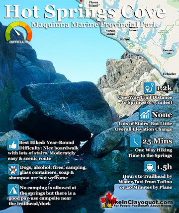
Hot Springs Cove is a wonderful day trip from Tofino. Lots of whale watching companies offer whale watching/hot springs tours for very reasonable prices. The boat ride is out on the open ocean is quite fun ...
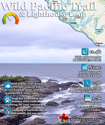
The Wild Pacific Trail is a must see on any visit to Pacific Rim National Park, Ucluelet and/or Tofino. Located in Ucluelet, the Wild Pacific Trail is actually a set of three trails that connect into a ...
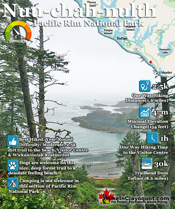
Meares Island was the centre of dispute in the 80's when the Nuu-chah-nulth protested Macmillan Bloedel's intent to log the island. The Nuu-chah-nulth together with environmental groups blockaded the island and ...
The Nuu-chah-nulth (aka the Wickaninnish Trail), has the amazing distinction among all the other beach hikes in the Tofino-Ucluelet corridor, in that it is flanked on one side by the amazing, and historic ...
Whistler is an amazing place to hike. Looking at a map of Whistler you see an extraordinary spider web of hiking trails. Easy trails, moderate trails and challenging hiking trails are all available. Another marvellous thing about Whistler is that Garibaldi Provincial ...
Squamish sits in the midst of some amazing places to hike. Garibaldi Park sprawls from Squamish up and beyond Whistler. Tantalus Provincial Park lays across the valley to the west and the beautiful and desolate, by comparison, Callaghan Valley to the north. Add to ...
Clayoquot Sound has a staggering array of hiking trails within it. Between Tofino and Ucluelet, Pacific Rim Park has several wilderness and beach trails, each one radically different from the last. The islands in the area are often Provincial parks on their own with ...
Victoria has a seemingly endless number of amazing hiking trails. Most take you to wild and beautiful Pacific Ocean views and others take you to tranquil lakes in beautiful BC Coastal Rainforest wilderness. Regional Parks and Provincial Parks are everywhere you turn ...
The West Coast Trail was created after decades of brutal and costly shipwrecks occurred along the West Coast of Vancouver Island. One shipwreck in particular was so horrific, tragic and unbelievable that it forced the creation of a trail along the coast, which ...