Clayoquot Sound has a staggering array of hiking trails within it. Between Tofino and Ucluelet, Pacific Rim National Park has several wilderness and beach trails, each one radically different from the last. The islands in the area are often separate Provincial Parks.
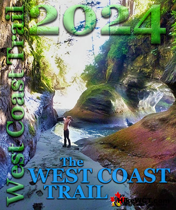
TheWestCoastTrail
The extraordinary West Coast Trail is found not far from Ucluelet. Bamfield is home to the northern trailhead to this wonderful trail known for its 80 foot ladders, stunning beaches and regular encounters with shipwrecks from the Graveyard of the Pacific.
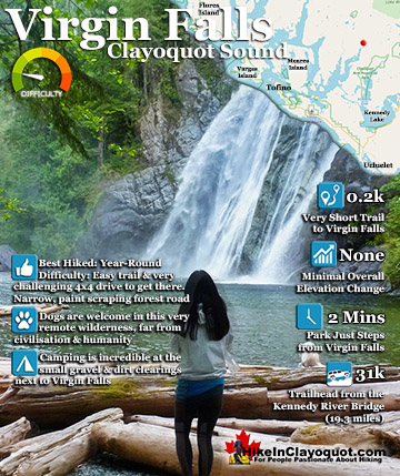
At 53 metres, Virgin Falls is quite an impressive sight. You walk through the short, two minute forest trail to reach it and it fills your view. It is located in a beautiful oasis it has created. A large, ice cold and crystal clear pool with pebble rocks and waterfall battered logs that flows out in a large, meandering stream through the trees. The whole area is surrounded by huge trees and you feel a strange sense of comfort, like you are in protected place. And when you roll out your sleeping bag in the spectacular setting, you will never want to leave.
The small, but very inviting camping area is amazing. Huge trees to your back, phenomenal waterfall to your front. Room for two tents near the cozy and clean fire pit. Endless firewood litters the edge of the waterfalls pool beautifully. Though the loud waterfall makes conversation a bit tough. The wonderful area where the fire is is somewhat sheltered by a couple large trees deflecting some sound and making the camping area all the better. The Virgin Falls Road is pretty bad, though very beautiful. It is hardly maintained, though still used logging road that hugs the coast much of its 31k length from the Kennedy River bridge turnoff. The potholes are numerous, though expected. What isn't expected is the narrow, overgrown sections. If you value your vehicles paint, you will find yourself gritting your teeth quite a bit. But then if you have a 4x4, you should likely be used to that and be fine barrelling through these narrow sections. If you are planning on driving up without a 4x4 you should be able to make it, though there are a couple of steep sections that you may have to make a couple runs at to get up. The hilariously adorable little cabin near Virgin Falls that can be used by anyone and sits at the end of a short side road definitely requires a good 4x4 to reach. But as it is only about 400 metres from the Virgin Falls road, you can park and walk to it if needed. There are two excellent pull out/turn around points on this short road as well in case you chicken out and want to turn around part way in.
The little Virgin Falls cabin is great for such a remote place. First off, the setting is fantastic. It is located overlooking the beautiful Tofino Creek, and there is a wonderful campfire spot complete with log seats, just steps from the cabin. The cabin itself is equipped with a wood stove and bunk beds. You could easily have 8 people stay and sleep fairly comfortably as there are six bunks and floor room. There are several empty and partly empty booze bottles lining the shelves as well as quite a few odd curiosities in the little cabin. If you are brave enough to drive right to the cabin there is room for several vehicles to park and not obstruct anyone's exit. The Virgin Falls cabin even has pots and pans for use with the stove and working lanterns and some fantastically kind people have generously equipped it with lots of cut firewood. There is a funny sign on the door declaring that the cabin is for everyone and despite its shabby appearance you get the impression that this cabin on Tofino Creek near Virgin Falls has been well used and well loved for decades.
Driving Directions to Virgin Falls
Though you have to travel a network of logging roads to reach Virgin Falls it is surprisingly easy to find it. The start of the Virgin Falls Road is immediately after the famous Kennedy River bridge. The focal point of the hugely publicized logging protests in 1993 where hundreds were arrested for blockading logging vehicles. The Kennedy River bridge is worth a look if you haven't taken a good look before. It spans the Kennedy River above the original and now crumbling, wooden bridge. The current one is a massive, solid steel bridge above the old one. Several wooden pilings are severely burned under the bridge during the protests. You can still see some burnt pilings if you look from the small boat launch area. To get to the Kennedy River bridge from the Pacific Rim Highway is easy. From the T junction where you either go to Tofino or Ucluelet or Port Alberni, drive for a couple kilometres in the direction of Port Alberni. Keep your eyes out on your left for the very visible though not well marked, West Main logging road. Follow the West Main for about 11k until you cross the large Kennedy River bridge. About 50 metres past it you will see the road branch off to the left unmarked but called the Deer Bay Rd on Google maps, but locally known as the Virgin Falls road.
Reset your odometer to zero and follow this road (bearing left at the Y junction a few minutes in). It is 31 kilometres(19.3 miles) from the Kennedy River Bridge turnoff to Virgin Falls. The Falls are impossible to miss as that can be easily seen and heard from a small logging road bridge just 100 metres before the trailhead. At 28 kilometres(17.4 miles) from the Kennedy River bridge you will see an overgrown road at a 90 degree angle on your left, this is a short road to a little cabin on the river. This road is extremely bad and overgrown, however if you are very confident in your 4x4 abilities and have a decent 4x4 you should make it. Certainly not a good idea to attempt this short road without some sort of self rescue equipment such as a winch. At least one deep washout may get you stuck. There is room for 4 vehicles at the edge of the Virgin Falls Road to park and its only about a 8 minute walk to the cabin. At 31k you will see Virgin Falls from the road, and about 100 metres (328 feet) after seeing it on your left you will spot the very visible trailhead a slight widening of the road to possibly accommodate two or three vehicles while allowing other vehicles to pass. The trail to the falls is less than a minute long.
The Best Tofino & Ucluelet Trails!
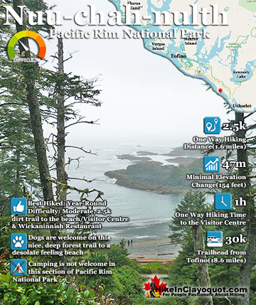
The Nuu-chah-nulth (aka the Wickaninnish Trail), has the amazing distinction among all the other beach hikes in the Tofino-Ucluelet corridor, in that it is flanked on one side by the amazing, and historic ...
At 53 metres, Virgin Falls is quite an impressive sight. You walk through the short, two minute forest trail to reach it and it fills your view. It is located in a beautiful oasis it has created. A large, ice ...
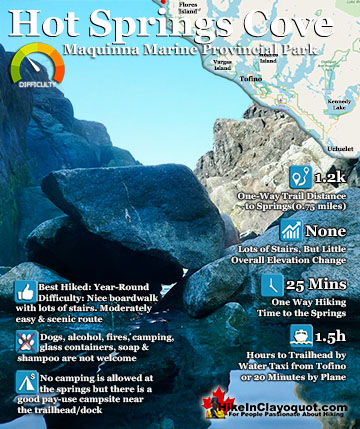
Hot Springs Cove is a wonderful day trip from Tofino. Lots of whale watching companies offer whale watching/hot springs tours for very reasonable prices. The boat ride is out on the open ocean is quite fun ...
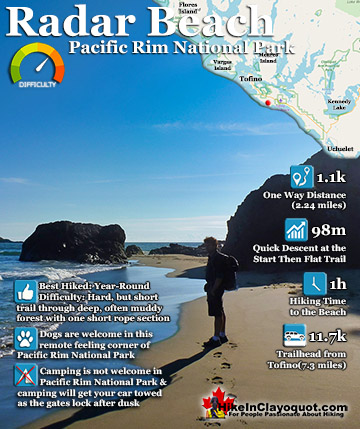
Radar Beach is one of the countless places that makes this part of the world so amazing. It is difficult to get to due to it having an unmarked trailhead, steep and muddy trail, and considerable climbing and ...
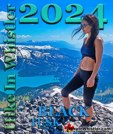
Whistler is an amazing place to hike. Looking at a map of Whistler you see an extraordinary spider web of hiking trails. Easy trails, moderate trails and challenging hiking trails are all available. Another marvellous thing about Whistler is that Garibaldi Provincial ...
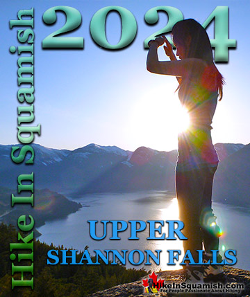
Squamish sits in the midst of some amazing places to hike. Garibaldi Park sprawls from Squamish up and beyond Whistler. Tantalus Provincial Park lays across the valley to the west and the beautiful and desolate, by comparison, Callaghan Valley to the north. Add to ...
Clayoquot Sound has a staggering array of hiking trails within it. Between Tofino and Ucluelet, Pacific Rim Park has several wilderness and beach trails, each one radically different from the last. The islands in the area are often Provincial parks on their own with ...
Victoria has a seemingly endless number of amazing hiking trails. Most take you to wild and beautiful Pacific Ocean views and others take you to tranquil lakes in beautiful BC Coastal Rainforest wilderness. Regional Parks and Provincial Parks are everywhere you turn ...
The West Coast Trail was created after decades of brutal and costly shipwrecks occurred along the West Coast of Vancouver Island. One shipwreck in particular was so horrific, tragic and unbelievable that it forced the creation of a trail along the coast, which ...